1.0 INTRODUCTION
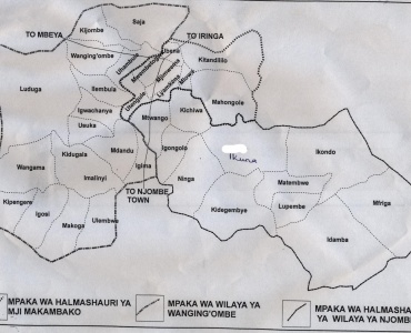
Njombe District Council was established in 1962 and later was dissolved on 1st, July 1972 by the Decentralization of Government Administration (Interim Provisions) Act No 27 of 1972 which was enacted by the Parliament of the United Republic of Tanzania and its function were transferred to District Development Councils. In 1983 the election in local government took place and Njombe District Council was re-established in 1984. In 2012 the District council was promoted to Njombe Region with 4 District Councils namely Njombe, Makete, Ludewa and Wanging’ombe District council; and two Town Councils of Njombe and Makambako Town Councils.
1.2 Geographical Location and Boundaries
Njombe District Council is located on the Southern Highlands and lies between attitudes 8.80 and 9.80 south of the Equator, and 34.50 – 35.80 Longitudes East of Greenwich. The Council is at latitude ranging from 1000 to 2000 meters above sea level. In the South Njombe District Council it borders Njombe Town Council where it extends up to south West, in the West it borders Wanging’ombe District, In the East it borders Morogoro Region and in the North it borders Mufindi District.
1.3 Land Area
The surface area of Njombe District Council is 3,134 square kilometers equivalent to 313,400 Hectares. Out of these 227,000 Hectares are suitable for agriculture and livestock production while the rest of the land is for other activities.
1.4 Climate
The mean annual rainfall at the highlands zone experiences reliable rainfall ranging between 900 - 1600 mm annually with lower temperature, largely humid lies below 150 C. while at the lower zone experiences unreliable rainfall ranging between 600 – 900mm annually, with relatively warm temperatures ranging between 15oC – 25oC, of which higher temperatures are experienced from September to November.
1.5 Administrative Units
Administratively the Council has one election constituency that is North Njombe which comprises 2 divisions, 12 wards, 45 villages, 227 sub-villages with 20,341 Households.
1.6 Population Size
Demographically, according to the National census of 2012, the District Council had a total population of 85,747 of whom 40,047 Male and 45,700 Female.
1.6 Ethnic Group
The dominant indigenous ethnic groups in Njombe District are the Bena, Hehe and Kinga. The customs and norms of indigenous tribes found in the district do resemble and have the same originality though the existing differences are due to subjection of economical and developmental changes.

Halmashauri ya Wilaya ya Njombe, Mtaa wa Kidegembye,Barabara ya Lupembe
Anuani ya Posta: S.L.P 547 Njombe
Namba ya Simu: +255 26 2782111
Simu Kiganjani:
Barua pepe: ded@njombedc.go.tz
Haki Miliki@2017 Halmashauri ya Wilaya ya Njombe. Haki zote zimehifadhiwa